Geolocate

Serangan topographic map

Click on the map to display elevation.

About this map

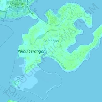
Name: Serangan topographic map, elevation, terrain.

Location: Serangan, Denpasar Selatan, Denpasar, Bali, Lesser Sunda Islands, Indonesia (-8.75254 115.21790 -8.72130 115.25089)

Average elevation: 3 ft

Minimum elevation: -7 ft

Maximum elevation: 23 ft

Other topographic maps

Click on a map to view its topography, its elevation and its terrain.

Sanur

Indonesia > Bali > Denpasar

Average elevation: 23 ft

Sesetan

Indonesia > Bali > Denpasar

Average elevation: 16 ft

park hayam wuruk

Indonesia > Bali > Denpasar

Average elevation: 89 ft

Lapangan Puputan Margarana

Indonesia > Bali > Denpasar

Average elevation: 49 ft

Gear up for your next adventure:

😴Insulated Sleeping Pads - Compact and warm pads for high-elevation camping
🪶LED Camping Lantern - Bright lantern for camp lighting
📶Satellite Messenger - Communication device off‑grid
🏕️Family Camping Gear - Essentials for group camping trips
📚Navigation Handbooks - Master the art of reading topographic maps and using a compass

As an Amazon Associate, this site earns from qualifying purchases at no extra cost to you.