
Țibănești topographic map
Interactive map
Click on the map to display elevation.
About this map
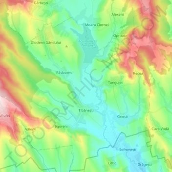
Name: Țibănești topographic map, elevation, terrain.
Location: Țibănești, Iași, Romania (46.86712 27.23462 46.97819 27.40056)
Average elevation: 761 ft
Minimum elevation: 427 ft
Maximum elevation: 1,480 ft
Other topographic maps
Click on a map to view its topography, its elevation and its terrain.
Mânzătești
Mânzătești, Ungheni, Iași Metropolitan Area, Iași, 707568, Romania
Average elevation: 243 ft
Târgu Frumos
Romania > Iași > Târgu Frumos
Târgu Frumos, Iași, 705300, Romania
Average elevation: 446 ft
Rusenii Vechi
Romania > Iași > Rusenii Vechi
Rusenii Vechi, Holboca, Iași Metropolitan Area, Iași, 707256, Romania
Average elevation: 348 ft