
Strawberry River topographic map
Interactive map
Click on the map to display elevation.
About this map
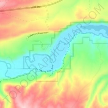
Name: Strawberry River topographic map, elevation, terrain.
Location: Strawberry River, Duchesne County, Utah, USA (40.15191 -110.56421 40.16595 -110.52364)
Average elevation: 6,030 ft
Minimum elevation: 5,702 ft
Maximum elevation: 6,411 ft
Other topographic maps
Click on a map to view its topography, its elevation and its terrain.
Timpanogos Glacier
USA > Utah > Aspen Grove
Timpanogos Glacier, Mount Timpanogos Trail #052, Aspen Grove, Utah County, Utah, USA
Average elevation: 10,328 ft
La Sal Mountains Viewpoint
La Sal Mountains Viewpoint, Arches Entrance Road, Grand County, Utah, 84532-2134, USA
Average elevation: 4,419 ft