
Make a donation
Gear up for your next adventure:
As an Amazon Associate, this site earns from qualifying purchases at no extra cost to you.
Buena Vista topographic map
Click on the map to display elevation.
Make a donation
Gear up for your next adventure:
As an Amazon Associate, this site earns from qualifying purchases at no extra cost to you.
About this map
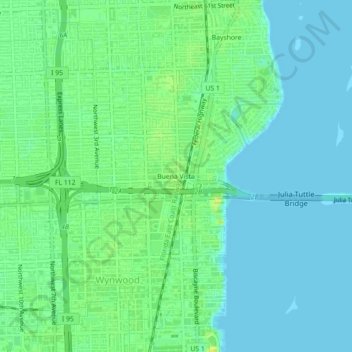
Name: Buena Vista topographic map, elevation, terrain.
Average elevation: 23 ft
Minimum elevation: -3 ft
Maximum elevation: 59 ft
Miami-Dade County trails, hiking, mountain biking, running and outdoor activities
Make a donation
Gear up for your next adventure:
As an Amazon Associate, this site earns from qualifying purchases at no extra cost to you.
Other topographic maps
Click on a map to view its topography, its elevation and its terrain.
Virginia Key Beach North Point Park
United States > Florida > Miami-Dade County > Miami
Average elevation: 10 ft
West Little River
United States > Florida > Miami-Dade County > Miami > West Little River
Average elevation: 23 ft