
Chaze topographic map
Interactive map
Click on the map to display elevation.
About this map
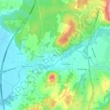
Name: Chaze topographic map, elevation, terrain.
Average elevation: 830 ft
Minimum elevation: 696 ft
Maximum elevation: 1,122 ft
Other topographic maps
Click on a map to view its topography, its elevation and its terrain.
Champagne
France > Bourgogne-Franche-Comté > Jura > Arlay
Champagne, Arlay, Lons-le-Saunier, Jura, Bourgogne-Franche-Comté, France métropolitaine, 39140, France
Average elevation: 840 ft
Arlay
France > Bourgogne-Franche-Comté > Jura > Arlay
Arlay, Lons-le-Saunier, Jura, Bourgogne-Franche-Comté, France métropolitaine, 39140, France
Average elevation: 817 ft