Geolocate

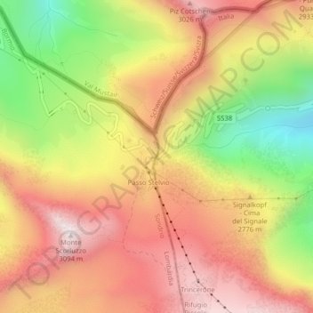
Passo dello Stelvio topographic map

Click on the map to display elevation.

Passo dello Stelvio

The Stelvio Pass (Italian: Passo dello Stelvio [passo ˈdello ˈstɛlvjo], Giogo dello Stelvio [dʒɔgo ˈdello ˈstɛlvjo]; German: Stilfser Joch; [ˈʃtɪlfsɐ jɔx]) is a mountain pass in northern Italy bordering Switzerland at an elevation of 2,757 m (9,045 ft) above sea level. It is the highest paved mountain pass in the Eastern Alps, and the second highest in the Alps, 7 m (23 ft) below France's Col de l'Iseran (2,764 m (9,068 ft)).

Wikipedia (CC-BY-SA 3.0)

About this map

Name: Passo dello Stelvio topographic map, elevation, terrain.

Location: Passo dello Stelvio, Stilfs - Stelvio, Vinschgau - Val Venosta, South Tyrol, Trentino-Alto Adige/Südtirol, 39029, Italy (46.52857 10.45316 46.52867 10.45326)

Average elevation: 8,937 ft

Minimum elevation: 7,418 ft

Maximum elevation: 10,089 ft

Gear up for your next adventure:

🛰️Satellite Messengers - Emergency SOS and two-way messaging for off-grid adventures
🪑Ultralight Camp Chairs - Portable seating for resting after a long day of mapping
🪶Camp Gear Gift Set - Perfect gift bundle for outdoor fans
🧦Merino Wool Socks - Moisture-wicking, blister-preventing socks for long treks
🛠️Outdoor Gear Repair Kit - Essential tools to fix gear on the trail

As an Amazon Associate, this site earns from qualifying purchases at no extra cost to you.