
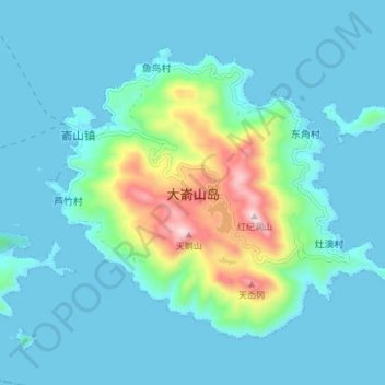
大嵛山岛 topographic map
Interactive map
Click on the map to display elevation.
About this map
Name: 大嵛山岛 topographic map, elevation, terrain.
Location: 大嵛山岛, 灶澳村, 嵛山镇, 福鼎市, 宁德市, 福建省, 中国 (26.92234 120.31587 26.97279 120.39067)
Average elevation: 262 ft
Minimum elevation: -3 ft
Maximum elevation: 1,726 ft
大嵛山岛是中國福建省宁德市福鼎市嵛山镇轄島,直径约5公里,面积21.22平方公里,最高处红纪洞山海拔541.4米,为闽东第一大岛,有2万亩天然草场。