
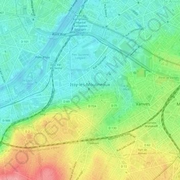
Issy-les-Moulineaux topographic map
Interactive map
Click on the map to display elevation.
About this map
Name: Issy-les-Moulineaux topographic map, elevation, terrain.
Average elevation: 197 ft
Minimum elevation: 85 ft
Maximum elevation: 410 ft
La superficie de la commune est de 425 hectares ; son altitude varie de 28 à 96 mètres.
Other topographic maps
Click on a map to view its topography, its elevation and its terrain.
La Garenne-Colombes
France > Île-de-France > Hauts-de-Seine
La Garenne-Colombes, Nanterre, Hauts-de-Seine, Île-de-France, France métropolitaine, 92250, France
Average elevation: 148 ft
Centre-Ville
France > Île-de-France > Hauts-de-Seine > Asnières-sur-Seine
Centre-Ville, Asnières-sur-Seine, Nanterre, Hauts-de-Seine, Île-de-France, France métropolitaine, 92600, France
Average elevation: 115 ft
Suresnes
France > Île-de-France > Hauts-de-Seine > Suresnes
Suresnes, Nanterre, Hauts-de-Seine, Île-de-France, France métropolitaine, 92150, France
Average elevation: 203 ft
Meudon
France > Île-de-France > Hauts-de-Seine
Meudon, Boulogne-Billancourt, Hauts-de-Seine, Île-de-France, France métropolitaine, France
Average elevation: 433 ft
Boulogne-Billancourt
France > Île-de-France > Hauts-de-Seine
Boulogne-Billancourt, Hauts-de-Seine, Île-de-France, France métropolitaine, 92100, France
Average elevation: 141 ft
Nanterre
France > Île-de-France > Hauts-de-Seine
Nanterre, Hauts-de-Seine, Île-de-France, France métropolitaine, 92000, France
Average elevation: 148 ft
Puteaux
France > Île-de-France > Hauts-de-Seine
Puteaux, Nanterre, Hauts-de-Seine, Île-de-France, France métropolitaine, 92800, France
Average elevation: 171 ft
Saint-Cloud
France > Île-de-France > Hauts-de-Seine
Saint-Cloud, Nanterre, Hauts-de-Seine, Île-de-France, France métropolitaine, 92210, France
Average elevation: 233 ft