
Burrville topographic map
Click on the map to display elevation.
About this map
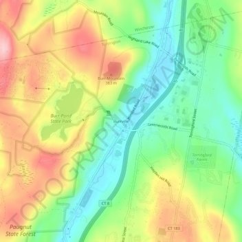
Name: Burrville topographic map, elevation, terrain.
Average elevation: 958 ft
Minimum elevation: 686 ft
Maximum elevation: 1,309 ft
Northwest Hills Planning Region trails, hiking, mountain biking, running and outdoor activities
Other topographic maps
Click on a map to view its topography, its elevation and its terrain.
Sharon Avenue Park
United States > Connecticut > Northwest Hills Planning Region > Torrington
Average elevation: 751 ft