
Osterode topographic map
Interactive map
Click on the map to display elevation.
About this map
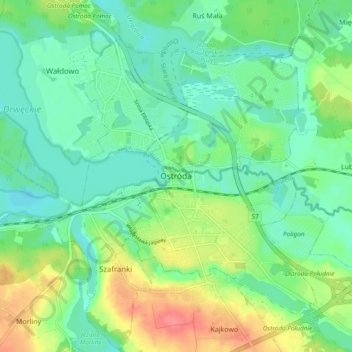
Name: Osterode topographic map, elevation, terrain.
Average elevation: 348 ft
Minimum elevation: 276 ft
Maximum elevation: 505 ft
Other topographic maps
Click on a map to view its topography, its elevation and its terrain.
Schönaich
Polen > Woiwodschaft Ermland-Masuren > powiat ostródzki
Schönaich, Gemeinde Liebemühl, powiat ostródzki, Woiwodschaft Ermland-Masuren, Polen
Average elevation: 341 ft
Wilhelmsthal
Polen > Woiwodschaft Ermland-Masuren > powiat ostródzki
Wilhelmsthal, Gemeinde Mohrungen, powiat ostródzki, Woiwodschaft Ermland-Masuren, 14-300, Polen
Average elevation: 492 ft
gmina Morąg
Polen > Woiwodschaft Ermland-Masuren > powiat ostródzki
gmina Morąg, powiat ostródzki, Woiwodschaft Ermland-Masuren, 14-300, Polen
Average elevation: 390 ft
Waldau
Polen > Woiwodschaft Ermland-Masuren > powiat ostródzki > Waldau
Waldau, gmina Ostróda, powiat ostródzki, Woiwodschaft Ermland-Masuren, Polen
Average elevation: 331 ft