
Make a donation
Gear up for your next adventure:
As an Amazon Associate, this site earns from qualifying purchases at no extra cost to you.
Bosio topographic map
Click on the map to display elevation.
Make a donation
Gear up for your next adventure:
As an Amazon Associate, this site earns from qualifying purchases at no extra cost to you.
About this map
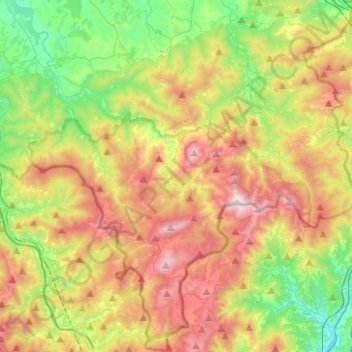
Name: Bosio topographic map, elevation, terrain.
Location: Bosio, Alessandria, Piedmont, Italy (44.48802 8.73142 44.66514 8.82904)
Average elevation: 1,742 ft
Minimum elevation: 233 ft
Maximum elevation: 3,816 ft
Make a donation
Gear up for your next adventure:
As an Amazon Associate, this site earns from qualifying purchases at no extra cost to you.
Other topographic maps
Click on a map to view its topography, its elevation and its terrain.
Make a donation
Gear up for your next adventure:
As an Amazon Associate, this site earns from qualifying purchases at no extra cost to you.
Make a donation
Gear up for your next adventure:
As an Amazon Associate, this site earns from qualifying purchases at no extra cost to you.
Silver poplar
Italy > Piedmont > Alessandria > Castelnuovo Scrivia > Il Secco
Average elevation: 259 ft