
Comala topographic map
Interactive map
Click on the map to display elevation.
About this map
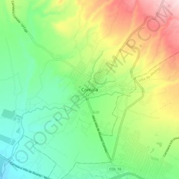
Name: Comala topographic map, elevation, terrain.
Location: Comala, Colima, 28450, México (19.28280 -103.79844 19.36280 -103.71844)
Average elevation: 2,090 ft
Minimum elevation: 1,522 ft
Maximum elevation: 3,114 ft
Other topographic maps
Click on a map to view its topography, its elevation and its terrain.
La Becerrera
La Becerrera, Comala, Colima, 28464, México
Average elevation: 4,213 ft
Parque "La Yerbabuena"
Parque "La Yerbabuena", Comala, Colima, 28460, México
Average elevation: 4,252 ft