
Jagodina City topographic map
Interactive map
Click on the map to display elevation.
About this map
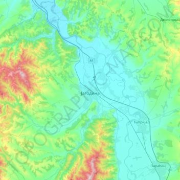
Name: Jagodina City topographic map, elevation, terrain.
Average elevation: 715 ft
Minimum elevation: 335 ft
Maximum elevation: 2,267 ft
Other topographic maps
Click on a map to view its topography, its elevation and its terrain.
Despotovac
Serbia > Central Serbia > Pomoravlje Administrative District > Despotovac Municipality
Despotovac, Despotovac Municipality, Pomoravlje Administrative District, Central Serbia, 35213, Serbia
Average elevation: 850 ft