
Make a donation
Gear up for your next adventure:
As an Amazon Associate, this site earns from qualifying purchases at no extra cost to you.
Anadarko topographic map
Click on the map to display elevation.
Make a donation
Gear up for your next adventure:
As an Amazon Associate, this site earns from qualifying purchases at no extra cost to you.
About this map
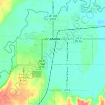
Name: Anadarko topographic map, elevation, terrain.
Location: Anadarko, Caddo County, Oklahoma, 73005, United States (35.03484 -98.27944 35.09436 -98.21401)
Average elevation: 1,211 ft
Minimum elevation: 1,152 ft
Maximum elevation: 1,378 ft
Caddo County trails, hiking, mountain biking, running and outdoor activities
Make a donation
Gear up for your next adventure:
As an Amazon Associate, this site earns from qualifying purchases at no extra cost to you.
Other topographic maps
Click on a map to view its topography, its elevation and its terrain.
Red Rock Canyon Adventure Park
United States > Oklahoma > Caddo County > Hinton
Average elevation: 1,614 ft
Make a donation
Gear up for your next adventure:
As an Amazon Associate, this site earns from qualifying purchases at no extra cost to you.