
Amdoun topographic map
Interactive map
Click on the map to display elevation.
About this map
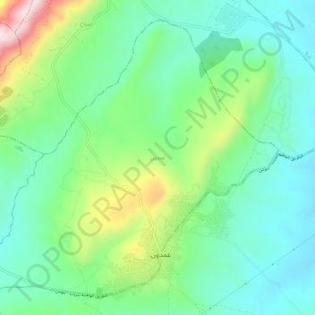
Name: Amdoun topographic map, elevation, terrain.
Location: Amdoun, Délégation Amdoun, Gouvernorat Béja, Tunisie (36.76293 9.05560 36.80082 9.10958)
Average elevation: 1,214 ft
Minimum elevation: 810 ft
Maximum elevation: 2,195 ft
Other topographic maps
Click on a map to view its topography, its elevation and its terrain.
Sidi Fredj
Sidi Fredj, Délégation Béja Sud, Gouvernorat Béja, Tunisie
Average elevation: 755 ft
Dougga
Dougga, Délégation Teboursouk, Gouvernorat Béja, Tunisie
Average elevation: 1,460 ft
Testour
Testour, Délégation Testour, Gouvernorat Béja, Tunisie
Average elevation: 423 ft
Nefza
Tunisie > Gouvernorat Béja > Nefza Ouest
Nefza, Nefza Ouest, Délégation Nefza, Gouvernorat Béja, 9010, Tunisie
Average elevation: 200 ft