
Thank you for supporting this site ❤️
Make a donation
Make a donation
Gear up for your next adventure:
As an Amazon Associate, this site earns from qualifying purchases at no extra cost to you.
Odersbach topographic map
Click on the map to display elevation.
Thank you for supporting this site ❤️
Make a donation
Make a donation
Gear up for your next adventure:
As an Amazon Associate, this site earns from qualifying purchases at no extra cost to you.
About this map
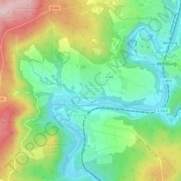
Name: Odersbach topographic map, elevation, terrain.
Location: Odersbach, Weilburg, Landkreis Limburg-Weilburg, Hesse, Germany (50.46233 8.21710 50.49280 8.26670)
Average elevation: 696 ft
Minimum elevation: 407 ft
Maximum elevation: 1,194 ft
Thank you for supporting this site ❤️
Make a donation
Make a donation
Gear up for your next adventure:
As an Amazon Associate, this site earns from qualifying purchases at no extra cost to you.