Geolocate

Tagudin topographic map

Click on the map to display elevation.

About this map

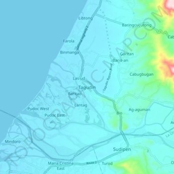
Name: Tagudin topographic map, elevation, terrain.

Location: Tagudin, Ilocos Sur, Ilocos Region, 2714, Philippines (16.89457 120.40502 16.97457 120.48502)

Average elevation: 79 ft

Minimum elevation: -7 ft

Maximum elevation: 1,086 ft

Other topographic maps

Click on a map to view its topography, its elevation and its terrain.

Bessang Pass

Philippines > Ilocos Sur

Average elevation: 4,518 ft

Gear up for your next adventure:

🪶Thermal Camp Blanket - Extra warmth for cold nights
📚USA Hiking Guide Books - Top trail guides and map books
🏔️Mountain Trail Maps - High‑detail maps for popular peaks
🦶Hiking Gaiters - Keep debris and water out of your boots
🪶Camping Sleeping Pad - Comfortable sleeping pad for backpacking

As an Amazon Associate, this site earns from qualifying purchases at no extra cost to you.