
Porrentruy topographic map
Interactive map
Click on the map to display elevation.
About this map
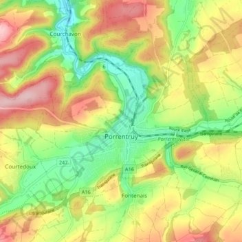
Name: Porrentruy topographic map, elevation, terrain.
Location: Porrentruy, District de Porrentruy, Jura, 2900, Switzerland (47.40041 7.02424 47.44083 7.10658)
Average elevation: 1,594 ft
Minimum elevation: 1,302 ft
Maximum elevation: 1,916 ft
Other topographic maps
Click on a map to view its topography, its elevation and its terrain.
Bure
Switzerland > Jura > District de Porrentruy
Bure, District de Porrentruy, Jura, 2915, Switzerland
Average elevation: 1,870 ft
Buix
Switzerland > Jura > District de Porrentruy > Basse-Allaine > Buix
Buix, Basse-Allaine, District de Porrentruy, Jura, 2925, Switzerland
Average elevation: 1,490 ft