
Balatonfüredi járás topographic map
Interactive map
Click on the map to display elevation.
About this map
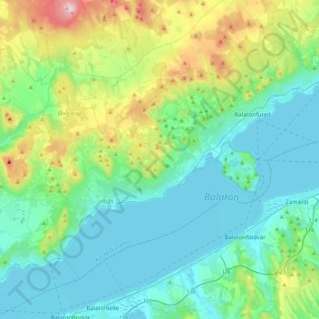
Name: Balatonfüredi járás topographic map, elevation, terrain.
Location: Balatonfüredi járás, Veszprém vármegye, Transdanubie, Hongrie (46.81208 17.62316 47.02127 18.03209)
Average elevation: 676 ft
Minimum elevation: 325 ft
Maximum elevation: 1,955 ft
Other topographic maps
Click on a map to view its topography, its elevation and its terrain.
Lac
Hongrie > Veszprém vármegye > Tés
Lac, Tés, Várpalotai járás, Veszprém vármegye, Transdanubie centrale, Transdanubie, 8109, Hongrie
Average elevation: 1,339 ft
Veszprém
Veszprém, Veszprémi járás, Veszprém vármegye, Transdanubie centrale, Transdanubie, Hongrie
Average elevation: 958 ft
Lac Balaton
Lac Balaton, Veszprém vármegye, Transdanubie centrale, Transdanubie, Hongrie
Average elevation: 627 ft