
Elkenrade topographic map
Interactive map
Click on the map to display elevation.
About this map
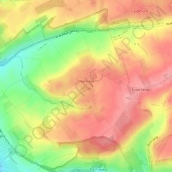
Name: Elkenrade topographic map, elevation, terrain.
Location: Elkenrade, Gulpen-Wittem, Limburg, Nederland (50.83121 5.89900 50.84889 5.93034)
Average elevation: 492 ft
Minimum elevation: 285 ft
Maximum elevation: 653 ft
Other topographic maps
Click on a map to view its topography, its elevation and its terrain.
Kasteel Wittem
Nederland > Limburg > Gulpen-Wittem
Kasteel Wittem, Voetpad Te Wittem, Wittem, Gulpen-Wittem, Limburg, Nederland, 6286AA, Nederland
Average elevation: 381 ft
Kasteel Neubourg
Nederland > Limburg > Gulpen-Wittem
Kasteel Neubourg, Riehagervoetpad, Gulpen, Gulpen-Wittem, Limburg, Nederland, 6271PL, Nederland
Average elevation: 449 ft