Geolocate

Rotonda topographic map

Click on the map to display elevation.

About this map

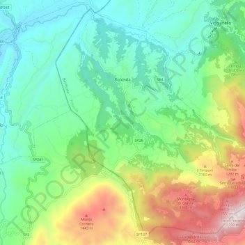
Name: Rotonda topographic map, elevation, terrain.

Location: Rotonda, Potenza, Basilicata, Italy (39.89581 16.00759 39.97854 16.12299)

Average elevation: 2,431 ft

Minimum elevation: 886 ft

Maximum elevation: 5,879 ft

Other topographic maps

Click on a map to view its topography, its elevation and its terrain.

Agri

Italy > Basilicata > Potenza > San Martino d'Agri

Average elevation: 1,611 ft

Gear up for your next adventure:

🔦LED Headlamp - Bright and durable LED headlamp for night navigation
🥄Camping Utensil Set - Lightweight utensils for outdoor meals
🎒Outdoor Daypacks - Lightweight backpacks designed for carrying maps and essential gear
📡GPS Antenna Upgrade - Enhance GPS reception in remote terrain
🕶️Glacier Sunglasses - Side shields to protect eyes from high-altitude snow glare

As an Amazon Associate, this site earns from qualifying purchases at no extra cost to you.