Geolocate

Boston topographic map

Click on the map to display elevation.

About this map

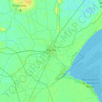
Name: Boston topographic map, elevation, terrain.

Location: Boston, Lincolnshire, England, United Kingdom (52.86280 -0.24671 53.08666 0.23855)

Average elevation: 10 ft

Minimum elevation: -7 ft

Maximum elevation: 46 ft

Other topographic maps

Click on a map to view its topography, its elevation and its terrain.

Stamford

United Kingdom > England > Lincolnshire > South Kesteven

Average elevation: 171 ft

Searby

United Kingdom > England > Lincolnshire > West Lindsey

Average elevation: 135 ft

Caistor

United Kingdom > England > Lincolnshire > West Lindsey

Average elevation: 259 ft

Harrowby

United Kingdom > England > Lincolnshire > South Kesteven

Average elevation: 328 ft

Dunston

United Kingdom > England > Lincolnshire > North Kesteven

Average elevation: 69 ft

Thurlby

United Kingdom > England > Lincolnshire > South Kesteven > Thurlby

Average elevation: 66 ft

Digby

United Kingdom > England > Lincolnshire > North Kesteven > Digby

Average elevation: 56 ft

Fosdyke

United Kingdom > England > Lincolnshire > Boston

Average elevation: 13 ft

Star Fen

United Kingdom > England > Lincolnshire > North Kesteven

Average elevation: 13 ft

Grantham

United Kingdom > England > Lincolnshire > South Kesteven

Average elevation: 285 ft

Gear up for your next adventure:

🍳Camping Cook Set - Complete cookware for outdoor meals
🖼️Topo Map Wall Art - Decorative topographic prints of famous peaks and regions
🚑Emergency Bivvies - Heat-reflective sleeping bags for survival situations
📦Dry Bags Set - Waterproof storage for electronics and clothes
🪶Survival Guide Book - Expert advice for emergency preparedness

As an Amazon Associate, this site earns from qualifying purchases at no extra cost to you.