
Make a donation
Gear up for your next adventure:
As an Amazon Associate, this site earns from qualifying purchases at no extra cost to you.
Chania topographic map
Click on the map to display elevation.
Make a donation
Gear up for your next adventure:
As an Amazon Associate, this site earns from qualifying purchases at no extra cost to you.
Chania
The climate in Chania is further complemented due to the terrain and can vary throughout its regions and elevations and according to its topography. At the south lies the mountain range of Lefka Ori. Furthermore, prevailing winds, such as those of the West side and South of Crete, in addition to the North side—all interact to form its climate.
Make a donation
Gear up for your next adventure:
As an Amazon Associate, this site earns from qualifying purchases at no extra cost to you.
About this map
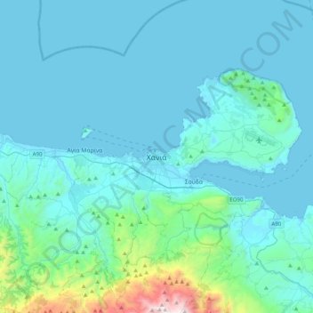
Name: Chania topographic map, elevation, terrain.
Average elevation: 636 ft
Minimum elevation: -3 ft
Maximum elevation: 6,729 ft
Make a donation
Gear up for your next adventure:
As an Amazon Associate, this site earns from qualifying purchases at no extra cost to you.
Other topographic maps
Click on a map to view its topography, its elevation and its terrain.
Municipality of Kantanos-Selinon
Greece > Region of Crete > Chania Regional Unit
Average elevation: 1,276 ft
Make a donation
Gear up for your next adventure:
As an Amazon Associate, this site earns from qualifying purchases at no extra cost to you.
Make a donation
Gear up for your next adventure:
As an Amazon Associate, this site earns from qualifying purchases at no extra cost to you.
Municipality of Kantanos-Selinon
Greece > Region of Crete > Chania Regional Unit
Average elevation: 1,276 ft
Make a donation
Gear up for your next adventure:
As an Amazon Associate, this site earns from qualifying purchases at no extra cost to you.