
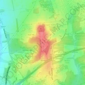
Toot Hill topographic map
Interactive map
Click on the map to display elevation.
About this map
Name: Toot Hill topographic map, elevation, terrain.
Average elevation: 148 ft
Minimum elevation: 43 ft
Maximum elevation: 282 ft
Other topographic maps
Click on a map to view its topography, its elevation and its terrain.
Redenham
United Kingdom > England > Test Valley > Redenham
Redenham, Test Valley, Hampshire, South East, England, SP11 9AY, United Kingdom
Average elevation: 371 ft
Romsey and Southampton North
United Kingdom > England > Test Valley
Romsey and Southampton North, Bossington, Test Valley, Hampshire, South East, England, United Kingdom
Average elevation: 246 ft
Michelmersh and Timsbury
United Kingdom > England > Test Valley
Michelmersh and Timsbury, Test Valley, Hampshire, South East, England, United Kingdom
Average elevation: 151 ft
Kimpton
United Kingdom > England > Test Valley
Kimpton, Test Valley, Hampshire, South East, England, United Kingdom
Average elevation: 364 ft
River Dever
United Kingdom > England > Test Valley
River Dever, Test Valley, Hampshire, South East, England, SO21 3QG, United Kingdom
Average elevation: 243 ft
Nursling and Rownhams
United Kingdom > England > Test Valley
Nursling and Rownhams, Test Valley, Hampshire, South East, England, United Kingdom
Average elevation: 102 ft
Valley Park
United Kingdom > England > Test Valley
Valley Park, Test Valley, Hampshire, South East, England, United Kingdom
Average elevation: 121 ft