Geolocate

Troutville topographic map

Click on the map to display elevation.

About this map

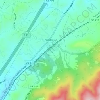
Name: Troutville topographic map, elevation, terrain.

Location: Troutville, Botetourt County, Virginia, United States (37.40423 -79.89041 37.42667 -79.86843)

Average elevation: 1,503 ft

Minimum elevation: 1,280 ft

Maximum elevation: 2,146 ft

Botetourt County trails, hiking, mountain biking, running and outdoor activities

Other topographic maps

Click on a map to view its topography, its elevation and its terrain.

Oriskany

United States > Virginia > Botetourt County

Average elevation: 1,325 ft

Eagle Rock

United States > Virginia > Botetourt County

Average elevation: 1,243 ft

Glen Wilton

United States > Virginia > Botetourt County

Average elevation: 1,191 ft

Daleville

United States > Virginia > Botetourt County

Average elevation: 1,345 ft

Sandbank Mountain

United States > Virginia > Botetourt County

Average elevation: 2,654 ft

Haden

United States > Virginia > Botetourt County > Haden

Average elevation: 1,112 ft

Gear up for your next adventure:

🧤Tactile Hiking Gloves - Keep hands warm while operating GPS and smartphone screens
🗻Climbing Gear Basics - Essential gear for beginner climbers
🧢Outdoor Hiking Hat - Sun protection hat for outdoor explorers
📚Navigation Handbooks - Master the art of reading topographic maps and using a compass
🔦Powerful Headlamps - Ultra-bright hands-free lighting for night navigation

As an Amazon Associate, this site earns from qualifying purchases at no extra cost to you.