Geolocate

Yarinacocha topographic map

Click on the map to display elevation.

About this map

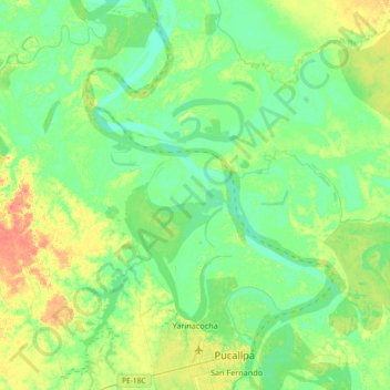
Name: Yarinacocha topographic map, elevation, terrain.

Location: Yarinacocha, Province of Coronel Portillo, Ucayali, Peru (-8.41434 -74.78053 -8.05197 -74.51276)

Average elevation: 472 ft

Minimum elevation: 433 ft

Maximum elevation: 554 ft

Other topographic maps

Click on a map to view its topography, its elevation and its terrain.

Paititi

Peru > Ucayali > Yurúa

Average elevation: 942 ft

Río Ucayali

Peru > Ucayali > Iparía

Average elevation: 528 ft

Gear up for your next adventure:

🛠️Outdoor Gear Repair Kit - Essential tools to fix gear on the trail
🔋Solar Power Banks - Keep your GPS and phone charged in remote wilderness areas
🪵Folding Camp Saw - Compact saw for wood and campsite work
🧭Outdoor Navigation Book - Learn advanced navigation skills
🔥Plasma Lighters - Windproof lighters that work in any weather condition

As an Amazon Associate, this site earns from qualifying purchases at no extra cost to you.