Geolocate

SITE Town topographic map

Click on the map to display elevation.

About this map

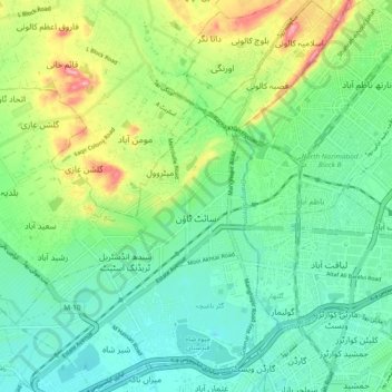
Name: SITE Town topographic map, elevation, terrain.

Location: SITE Town, Keamari District, Karachi Division, Sindh, Pakistan (24.87492 66.96289 24.96071 67.04087)

Average elevation: 125 ft

Minimum elevation: 0 ft

Maximum elevation: 407 ft

Other topographic maps

Click on a map to view its topography, its elevation and its terrain.

North Karachi

Pakistan > Sindh > Karachi Division

Average elevation: 174 ft

Saddar

Pakistan > Sindh > Karachi Division

Average elevation: 46 ft

Gear up for your next adventure:

🪑Portable Camp Table - Compact table for campsite meals
🛡️Bear Spray Outdoor - Protection in bear country hikes
📚USA Hiking Guide Books - Top trail guides and map books
🏕️Family Camping Gear - Essentials for group camping trips
🛠️Backpacking Tool Kit - Essential toolkit for outdoor repairs

As an Amazon Associate, this site earns from qualifying purchases at no extra cost to you.