
Make a donation
Gear up for your next adventure:
As an Amazon Associate, this site earns from qualifying purchases at no extra cost to you.
Iron Mountain topographic map
Click on the map to display elevation.
Make a donation
Gear up for your next adventure:
As an Amazon Associate, this site earns from qualifying purchases at no extra cost to you.
Iron Mountain
Iron Mountain is included in the Marquette television market, NBC affiliate WLUC operates a local news bureau covering the city and neighboring areas. Due to distance from the transmitters and topography in the region terrestrial television signals are very limited in the area with the strongest signal coming from Wisconsin Public Television translator station W30DZ originating from Fence, WI.
Make a donation
Gear up for your next adventure:
As an Amazon Associate, this site earns from qualifying purchases at no extra cost to you.
About this map
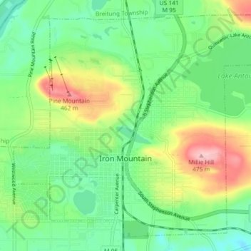
Name: Iron Mountain topographic map, elevation, terrain.
Location: Iron Mountain, Dickinson County, Michigan, United States (45.80456 -88.09815 45.84894 -88.02630)
Average elevation: 1,198 ft
Minimum elevation: 997 ft
Maximum elevation: 1,581 ft
Dickinson County trails, hiking, mountain biking, running and outdoor activities
Make a donation
Gear up for your next adventure:
As an Amazon Associate, this site earns from qualifying purchases at no extra cost to you.
Other topographic maps
Click on a map to view its topography, its elevation and its terrain.
Felch Mountain
United States > Michigan > Dickinson County > Felch Township > Felch
Average elevation: 1,161 ft
Make a donation
Gear up for your next adventure:
As an Amazon Associate, this site earns from qualifying purchases at no extra cost to you.