Geolocate

Mount Marapi topographic map

Click on the map to display elevation.

About this map

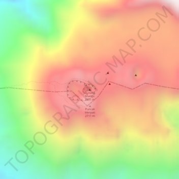
Name: Mount Marapi topographic map, elevation, terrain.

Location: Mount Marapi, Agam, West Sumatra, Sumatra, Indonesia (-0.39116 100.45709 -0.39106 100.45719)

Average elevation: 8,061 ft

Minimum elevation: 6,342 ft

Maximum elevation: 9,337 ft

Gear up for your next adventure:

🪶Fire Starter Kit - Reliable fire starter for survival and camping
❄️Traction Cleats - Prevent slips on icy trails during winter hikes
🥇GPS Hiking Watch - Multi‑sport GPS watch with navigation and trail tracking
🪵Folding Camp Saw - Compact saw for wood and campsite work
🥾Men's Hiking Boots - Durable, waterproof footwear for rugged terrain and steep inclines

As an Amazon Associate, this site earns from qualifying purchases at no extra cost to you.