
Neukölln topographic map
Interactive map
Click on the map to display elevation.
About this map
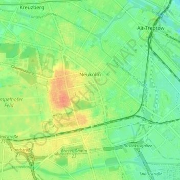
Name: Neukölln topographic map, elevation, terrain.
Location: Neukölln, Berlin, Germany (52.45876 13.40608 52.49587 13.47855)
Average elevation: 141 ft
Minimum elevation: 85 ft
Maximum elevation: 220 ft
Neukölln lies on the geological border between the shallow Berliner Urstromtal glacial valley and the Tempelhofer Berge, which are situated in the northernmost region of the Teltow ground moraine plateau, rising to the south of Hermannplatz, in what is mostly the typical low-lying marshy woodlands with a mainly flat topography of the North European Plain.
Other topographic maps
Click on a map to view its topography, its elevation and its terrain.
Friedrichshain-Kreuzberg
Friedrichshain-Kreuzberg, Berlin, Germany
Average elevation: 148 ft
Charlottenburg-Wilmersdorf
Charlottenburg-Wilmersdorf, Berlin, Germany
Average elevation: 144 ft
Volkspark Friedrichshain
Volkspark Friedrichshain, Barnimkiez, Friedrichshain, Friedrichshain-Kreuzberg, Berlin, 10249, Germany
Average elevation: 161 ft
Charlottenburg
Charlottenburg, Charlottenburg-Wilmersdorf, Berlin, Germany
Average elevation: 135 ft
Biesenhorster Sand
Biesenhorster Sand, Tangentiale Verbindung Ost, , Biesdorf, Marzahn-Hellersdorf, Berlin, 12683, Germany
Average elevation: 125 ft
Volkspark am Weinberg
Volkspark am Weinberg, Spandauer Vorstadt, Mitte, Berlin, 10119, Germany
Average elevation: 154 ft