Geolocate

Paradise topographic map

Click on the map to display elevation.

Paradise

Paradise lies within the foothills of the Sierra Nevada mountain range, at an elevation that varies between 900 and 2,300 feet (275 to 700 meters) above sea level. The town is perched on a broad ridge, with steep canyons on either side—these are carved by the Feather River to the east and Butte Creek to the west. This topographical setting creates dramatic views of the surrounding landscape, with steep inclines and rugged terrain. As you move northward from Paradise, the elevation steadily increases, offering sweeping vistas of the nearby valleys. The area is known for its mountainous, forested terrain, which is rich in natural beauty but can be challenging due to its hilly and uneven landscape.

About this map

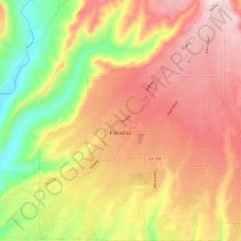
Name: Paradise topographic map, elevation, terrain.

Location: Paradise, Butte County, California, 95969, United States (39.72536 -121.65565 39.80154 -121.56445)

Average elevation: 1,522 ft

Minimum elevation: 456 ft

Maximum elevation: 2,382 ft

Butte County trails, hiking, mountain biking, running and outdoor activities

Other topographic maps

Click on a map to view its topography, its elevation and its terrain.

Big Bend

United States > California > Butte County

Average elevation: 1,883 ft

Magalia

United States > California > Butte County

Average elevation: 2,047 ft

Hurleton

United States > California > Butte County

Average elevation: 1,742 ft

Wyandotte

United States > California > Butte County

Average elevation: 666 ft

Big Bend Mountain

United States > California > Butte County

Average elevation: 2,267 ft

Berry Creek

United States > California > Butte County

Average elevation: 2,287 ft

Butte Meadows

United States > California > Butte County

Average elevation: 4,524 ft

Paradise Pines

United States > California > Butte County > Magalia

Average elevation: 2,375 ft

Barber

United States > California > Butte County > Chico

Average elevation: 194 ft

Forest Ranch

United States > California > Butte County

Average elevation: 2,205 ft

Palermo

United States > California > Butte County

Average elevation: 197 ft

Cherokee

United States > California > Butte County

Average elevation: 1,178 ft

Inskip

United States > California > Butte County

Average elevation: 4,521 ft

Magalia

United States > California > Butte County

Average elevation: 2,280 ft

Stirling City

United States > California > Butte County

Stirling City is a census-designated place in Butte County, California, located on Paradise Ridge in the western foothills of the Sierra Nevada. Contrary to its name, Stirling City is not a city. Its ZIP Code is 95978 and area code 530. It lies at an elevation of 3570 feet (1088 m). Stirling City had a…

Average elevation: 3,425 ft

Clipper Mills

United States > California > Butte County

Average elevation: 3,478 ft

Sky High

United States > California > Butte County

Average elevation: 3,169 ft

Cohasset

United States > California > Butte County

Average elevation: 2,549 ft

Paradise Dam

United States > California > Butte County

Average elevation: 2,589 ft

Merrimac

United States > California > Butte County

Average elevation: 3,907 ft

Paradise Pines

United States > California > Butte County

Average elevation: 2,375 ft

Peachton

United States > California > Butte County

Average elevation: 98 ft

Pulga

United States > California > Butte County

Average elevation: 2,461 ft

Gear up for your next adventure:

🚗GPS Dash Cams - Record your scenic drives through mountain passes and canyons
🪓Survival Multi‑Tool - Versatile tool for camp and trail tasks
🔥Plasma Lighters - Windproof lighters that work in any weather condition
📻Weather Alert Radios - Stay informed of storm risks while off-the-grid
🗺️NatGeo Topo Maps - High-quality waterproof printed topographic maps of US Parks

As an Amazon Associate, this site earns from qualifying purchases at no extra cost to you.