
Make a donation
Gear up for your next adventure:
As an Amazon Associate, this site earns from qualifying purchases at no extra cost to you.
West Woodstock topographic map
Click on the map to display elevation.
Make a donation
Gear up for your next adventure:
As an Amazon Associate, this site earns from qualifying purchases at no extra cost to you.
About this map
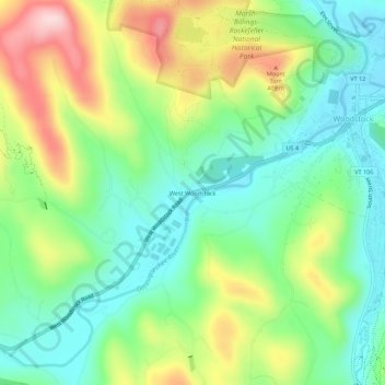
Name: West Woodstock topographic map, elevation, terrain.
Average elevation: 974 ft
Minimum elevation: 663 ft
Maximum elevation: 1,532 ft
Windsor County trails, hiking, mountain biking, running and outdoor activities
Make a donation
Gear up for your next adventure:
As an Amazon Associate, this site earns from qualifying purchases at no extra cost to you.
Other topographic maps
Click on a map to view its topography, its elevation and its terrain.
South Woodstock
United States > Vermont > Windsor County > Woodstock
South Woodstock is an unincorporated village and census-designated place (CDP) in the town of Woodstock in Windsor County, Vermont, United States. Its elevation is 1,040 feet (320 m), and it is located at 43°33′56″N 72°31′56″W / 43.56556°N 72.53222°W / 43.56556; -72.53222 (43.5656256,…
Average elevation: 1,263 ft