
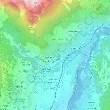
Fontfourane topographic map
Interactive map
Click on the map to display elevation.
About this map
Name: Fontfourane topographic map, elevation, terrain.
Average elevation: 3,789 ft
Minimum elevation: 2,710 ft
Maximum elevation: 7,277 ft
Other topographic maps
Click on a map to view its topography, its elevation and its terrain.
Les Chamousses
France > Provence-Alpes-Côte d'Azur > Hautes-Alpes > Saint-Marcelin
Les Chamousses, Saint-Marcelin, Châteauroux-les-Alpes, Gap, Hautes-Alpes, Provence-Alpes-Côte d'Azur, France métropolitaine, 05380, France
Average elevation: 4,117 ft
Les Peschiers
France > Provence-Alpes-Côte d'Azur > Hautes-Alpes > Saint-Marcelin
Les Peschiers, Saint-Marcelin, Châteauroux-les-Alpes, Gap, Hautes-Alpes, Provence-Alpes-Côte d'Azur, France métropolitaine, 05380, France
Average elevation: 3,386 ft
Saint-Étienne
France > Provence-Alpes-Côte d'Azur > Hautes-Alpes > Saint-Marcelin
Saint-Étienne, Saint-Marcelin, Châteauroux-les-Alpes, Gap, Hautes-Alpes, Provence-Alpes-Côte d'Azur, France métropolitaine, 05380, France
Average elevation: 4,167 ft
Les Alpes
France > Provence-Alpes-Côte d'Azur > Hautes-Alpes > Saint-Marcelin
Les Alpes, Saint-Marcelin, Châteauroux-les-Alpes, Gap, Hautes-Alpes, Provence-Alpes-Côte d'Azur, France métropolitaine, 05380, France
Average elevation: 3,520 ft