
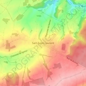
Sart-Saint-Laurent topographic map
Interactive map
Click on the map to display elevation.
About this map
Name: Sart-Saint-Laurent topographic map, elevation, terrain.
Average elevation: 689 ft
Minimum elevation: 436 ft
Maximum elevation: 879 ft
Other topographic maps
Click on a map to view its topography, its elevation and its terrain.
Sart-Eustache
België > Namen > Namen > Fosses-la-Ville
Sart-Eustache, Fosses-la-Ville, Namen, Wallonië, 5070, België
Average elevation: 604 ft
Aisemont
België > Namen > Namen > Fosses-la-Ville
Aisemont, Fosses-la-Ville, Namen, Wallonië, 5070, België
Average elevation: 574 ft