
Elahiyeh topographic map
Interactive map
Click on the map to display elevation.
About this map
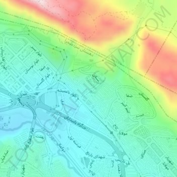
Name: Elahiyeh topographic map, elevation, terrain.
Average elevation: 5,200 ft
Minimum elevation: 4,810 ft
Maximum elevation: 6,093 ft
Other topographic maps
Click on a map to view its topography, its elevation and its terrain.
Tabriz
Iran > East Azerbaijan Province > Tabriz
Tabriz, بخش مرکزی شهرستان تبریز, Tabriz County, East Azerbaijan Province, 5137653515, Iran
Average elevation: 5,230 ft
Safire omid town
Iran > East Azerbaijan Province > Tabriz
Safire omid town, Zanginova, Tabriz, بخش مرکزی شهرستان تبریز, Tabriz County, East Azerbaijan Province, Iran
Average elevation: 4,678 ft