
Varessia topographic map
Interactive map
Click on the map to display elevation.
About this map
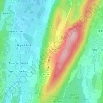
Name: Varessia topographic map, elevation, terrain.
Average elevation: 1,736 ft
Minimum elevation: 1,532 ft
Maximum elevation: 2,185 ft
Other topographic maps
Click on a map to view its topography, its elevation and its terrain.
Arthenas
France > Bourgogne-Franche-Comté > Jura > La Chailleuse
Arthenas, La Chailleuse, Lons-le-Saunier, Jura, Bourgogne-Franche-Comté, France métropolitaine, 39270, France
Average elevation: 1,640 ft
Essia
France > Bourgogne-Franche-Comté > Jura > La Chailleuse
Essia, La Chailleuse, Lons-le-Saunier, Jura, Bourgogne-Franche-Comté, France métropolitaine, 39270, France
Average elevation: 1,729 ft