
Lalutaya Island topographic map
Interactive map
Click on the map to display elevation.
About this map
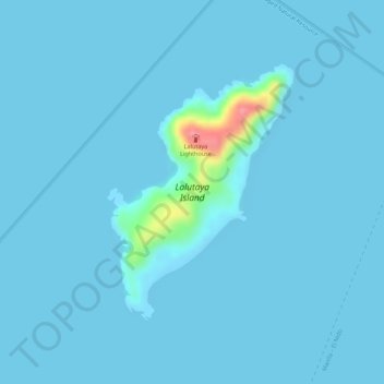
Name: Lalutaya Island topographic map, elevation, terrain.
Location: Lalutaya Island, El Nido, Palawan, Mimaropa, Philippines (11.34931 119.40461 11.36735 119.41799)
Average elevation: 16 ft
Minimum elevation: 0 ft
Maximum elevation: 325 ft
Other topographic maps
Click on a map to view its topography, its elevation and its terrain.
Sibaltan
Philippines > Palawan > El Nido
Sibaltan, El Nido, Palawan, Mimaropa, Philippines
Average elevation: 62 ft
Nacpan Beach
Philippines > Palawan > El Nido > Calitang
Nacpan Beach, Calitang, El Nido, Palawan, Mimaropa, Philippines
Average elevation: 118 ft
Cadlao Island
Philippines > Palawan > El Nido
Cadlao Island, El Nido, Palawan, Mimaropa, 5313, Philippines
Average elevation: 131 ft