
Bajrambos topographic map
Interactive map
Click on the map to display elevation.
About this map
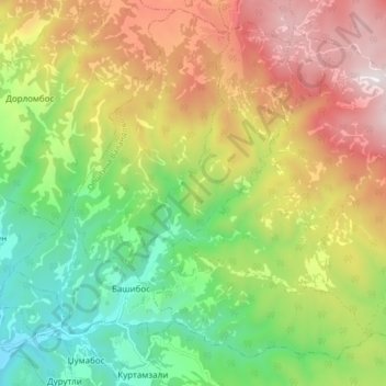
Name: Bajrambos topographic map, elevation, terrain.
Average elevation: 2,116 ft
Minimum elevation: 551 ft
Maximum elevation: 4,154 ft
Other topographic maps
Click on a map to view its topography, its elevation and its terrain.
Sevendekli
North Macedonia > Southeastern Region
Sevendekli, Municipality of Dojran, Southeastern Region, North Macedonia
Average elevation: 1,365 ft
Petrovo
North Macedonia > Southeastern Region
Petrovo, Municipality of Gevgelija, Southeastern Region, North Macedonia
Average elevation: 1,463 ft
Gjuleli
North Macedonia > Southeastern Region > Gjuleli
Gjuleli, Municipality of Valandovo, Southeastern Region, North Macedonia
Average elevation: 728 ft
Lake of Dojran
North Macedonia > Southeastern Region > Star Dojran
Lake of Dojran, Star Dojran, Municipality of Dojran, Southeastern Region, North Macedonia
Average elevation: 531 ft