
Diriá (Municipio) topographic map
Interactive map
Click on the map to display elevation.
About this map
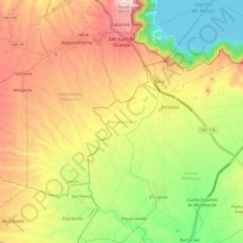
Name: Diriá (Municipio) topographic map, elevation, terrain.
Location: Diriá (Municipio), Granada, 44200, Nicaragua (11.81265 -86.09354 11.92344 -86.00343)
Average elevation: 1,079 ft
Minimum elevation: 226 ft
Maximum elevation: 1,988 ft
Other topographic maps
Click on a map to view its topography, its elevation and its terrain.