
Herlazhofen topographic map
Interactive map
Click on the map to display elevation.
About this map
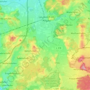
Name: Herlazhofen topographic map, elevation, terrain.
Average elevation: 2,267 ft
Minimum elevation: 2,070 ft
Maximum elevation: 2,631 ft
Other topographic maps
Click on a map to view its topography, its elevation and its terrain.
Reichenhofen
Deutschland > Baden-Württemberg > Leutkirch im Allgäu
Reichenhofen, Leutkirch im Allgäu, Verwaltungsgemeinschaft Leutkirch im Allgäu, Landkreis Ravensburg, Regierungsbezirk Tübingen, Baden-Württemberg, Deutschland
Average elevation: 2,267 ft