
Le Presbytère topographic map
Interactive map
Click on the map to display elevation.
About this map
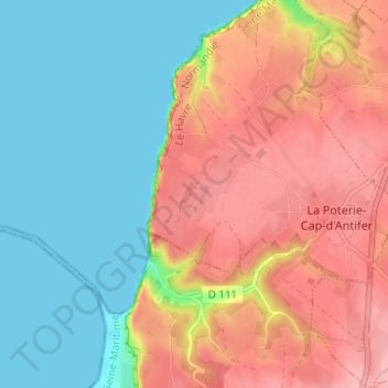
Name: Le Presbytère topographic map, elevation, terrain.
Average elevation: 184 ft
Minimum elevation: 0 ft
Maximum elevation: 404 ft
Other topographic maps
Click on a map to view its topography, its elevation and its terrain.
Jumel
France > Normandie > Seine-Maritime > La Poterie-Cap-d'Antifer > Jumel
Jumel, La Poterie-Cap-d'Antifer, Le Havre, Seine-Maritime, Normandie, France métropolitaine, 76280, France
Average elevation: 213 ft