
Schnidehorn topographic map
Interactive map
Click on the map to display elevation.
About this map
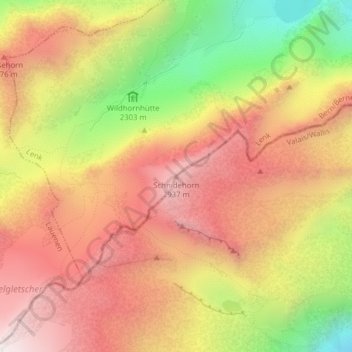
Name: Schnidehorn topographic map, elevation, terrain.
Location: Schnidehorn, Ayent, Hérens, Vallese, 1966, Svizzera (46.37302 7.39274 46.37312 7.39284)
Average elevation: 8,419 ft
Minimum elevation: 6,480 ft
Maximum elevation: 9,816 ft
Other topographic maps
Click on a map to view its topography, its elevation and its terrain.
Rohrbachstein
Rohrbachstein, Ayent, Hérens, Vallese, 1966, Svizzera
Average elevation: 8,540 ft
Lac de Tseuzier
Lac de Tseuzier, Tseuzier, Ayent, Hérens, Vallese, 1966, Svizzera
Average elevation: 6,598 ft