
Erlmühle topographic map
Interactive map
Click on the map to display elevation.
About this map
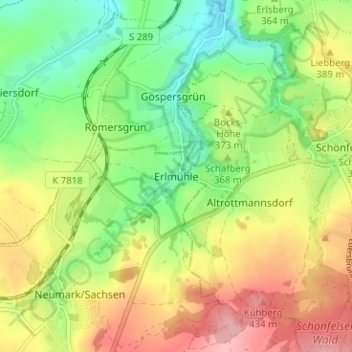
Name: Erlmühle topographic map, elevation, terrain.
Location: Erlmühle, Neumark, Vogtlandkreis, Sachsen, 08496, Deutschland (50.65096 12.35530 50.69096 12.39530)
Average elevation: 1,201 ft
Minimum elevation: 1,004 ft
Maximum elevation: 1,447 ft
Other topographic maps
Click on a map to view its topography, its elevation and its terrain.
Reuth
Deutschland > Sachsen > Vogtlandkreis > Neumark > Reuth
Reuth, Neumark, Vogtlandkreis, Sachsen, 08496, Deutschland
Average elevation: 1,230 ft