
Rastede topographic map
Interactive map
Click on the map to display elevation.
About this map
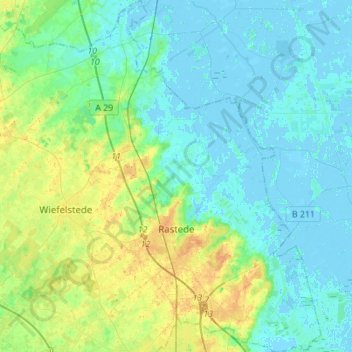
Name: Rastede topographic map, elevation, terrain.
Location: Rastede, Landkreis Ammerland, Lower Saxony, 26180, Germany (53.18890 8.10537 53.35415 8.31573)
Average elevation: 23 ft
Minimum elevation: -13 ft
Maximum elevation: 82 ft
Other topographic maps
Click on a map to view its topography, its elevation and its terrain.
Edewecht
Germany > Lower Saxony > Landkreis Ammerland
Edewecht, Landkreis Ammerland, Lower Saxony, 26188, Germany
Average elevation: 26 ft
Bad Zwischenahn
Germany > Lower Saxony > Landkreis Ammerland
Bad Zwischenahn, Landkreis Ammerland, Lower Saxony, 26160, Germany
Average elevation: 30 ft