
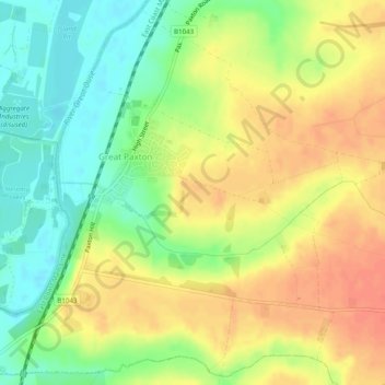
Great Paxton topographic map
Interactive map
Click on the map to display elevation.
About this map
Name: Great Paxton topographic map, elevation, terrain.
Average elevation: 112 ft
Minimum elevation: 30 ft
Maximum elevation: 184 ft
Other topographic maps
Click on a map to view its topography, its elevation and its terrain.
Kimbolton
United Kingdom > England > Cambridgeshire > Huntingdonshire > Kimbolton
Kimbolton, Huntingdonshire, Cambridgeshire, Cambridgeshire and Peterborough, England, United Kingdom
Average elevation: 177 ft
Godmanchester
United Kingdom > England > Cambridgeshire > Huntingdonshire
Huntingdon, Godmanchester, Huntingdonshire, Cambridgeshire, Cambridgeshire and Peterborough, England, United Kingdom
Average elevation: 82 ft
Holme
United Kingdom > England > Cambridgeshire > Huntingdonshire
Holme, Huntingdonshire, Cambridgeshire, Cambridgeshire and Peterborough, England, United Kingdom
Average elevation: 3 ft