
Lamadrid topographic map
Interactive map
Click on the map to display elevation.
About this map
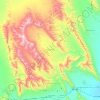
Name: Lamadrid topographic map, elevation, terrain.
Location: Lamadrid, Coahuila, México (27.02102 -102.09743 27.30557 -101.71006)
Average elevation: 3,990 ft
Minimum elevation: 1,873 ft
Maximum elevation: 7,552 ft
Other topographic maps
Click on a map to view its topography, its elevation and its terrain.
28 de Agosto
28 de Agosto, Parras, Coahuila, 27990, México
Average elevation: 3,901 ft
Ramos Arizpe
México > Coahuila > Ramos Arizpe
Ramos Arizpe, Coahuila, 25900, México
Average elevation: 4,678 ft
Landeros
México > Coahuila > Ramos Arizpe > Landeros
Landeros, Ramos Arizpe, Coahuila, México
Average elevation: 5,062 ft
Piedras Negras
México > Coahuila > Municipio de Piedras Negras > Piedras Negras
Piedras Negras, Municipio de Piedras Negras, Coahuila, 26085, México
Average elevation: 843 ft