
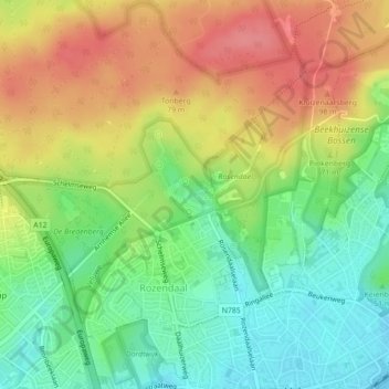
Kasteel Rosendael topographic map
Interactive map
Click on the map to display elevation.
About this map
Name: Kasteel Rosendael topographic map, elevation, terrain.
Average elevation: 180 ft
Minimum elevation: 56 ft
Maximum elevation: 322 ft
Other topographic maps
Click on a map to view its topography, its elevation and its terrain.
Imbosch
Nederland > Gelderland > Rozendaal
Imbosch, Rozendaal, Gelderland, Nederland, 6891 DZ, Nederland
Average elevation: 233 ft
Rozendaal
Nederland > Gelderland > Rozendaal
Rozendaal, Gelderland, Nederland
Average elevation: 217 ft
Imbosch
Nederland > Gelderland > Rozendaal
Imbosch, Rozendaal, Gelderland, Nederland, 6961 LJ, Nederland
Average elevation: 210 ft