
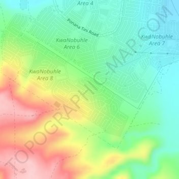
Nelson Mandela Bay Ward 42 topographic map
Interactive map
Click on the map to display elevation.
About this map
Name: Nelson Mandela Bay Ward 42 topographic map, elevation, terrain.
Average elevation: 407 ft
Minimum elevation: 184 ft
Maximum elevation: 758 ft
Other topographic maps
Click on a map to view its topography, its elevation and its terrain.
Swartkops River
RSA > Eastern Cape > Port Elizabeth
Swartkops River, Port Elizabeth, Nelson Mandela Bay Metropolitan Municipality, Eastern Cape, 6229, RSA
Average elevation: 272 ft
Nelson Mandela Bay Ward 1
RSA > Eastern Cape > Port Elizabeth
Nelson Mandela Bay Ward 1, Port Elizabeth, Nelson Mandela Bay Metropolitan Municipality, Eastern Cape, 6070, RSA
Average elevation: 249 ft
Brenton Island
RSA > Eastern Cape > Port Elizabeth
Brenton Island, Port Elizabeth, Eastern Cape, RSA
Average elevation: 0 ft
Nelson Mandela Bay Ward 41
RSA > Eastern Cape > Port Elizabeth
Nelson Mandela Bay Ward 41, Port Elizabeth, Nelson Mandela Bay Metropolitan Municipality, Eastern Cape, RSA
Average elevation: 344 ft
Jahleel Island
RSA > Eastern Cape > Port Elizabeth
Jahleel Island, Port Elizabeth, Eastern Cape, RSA
Average elevation: 3 ft