
Ashkelon topographic map
Interactive map
Click on the map to display elevation.
About this map
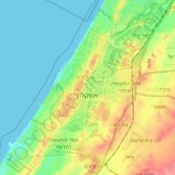
Name: Ashkelon topographic map, elevation, terrain.
Location: Ashkelon, Ashkelon Subdistrict, South District, Israel (31.61970 34.49202 31.71822 34.61425)
Average elevation: 95 ft
Minimum elevation: -3 ft
Maximum elevation: 282 ft
Other topographic maps
Click on a map to view its topography, its elevation and its terrain.
Ashkelon National Park
Israel > South District > Ashkelon
Ashkelon National Park, Ashkelon, Ashkelon Subdistrict, South District, Israel
Average elevation: 75 ft