Geolocate

Zeutern topographic map

Click on the map to display elevation.

About this map

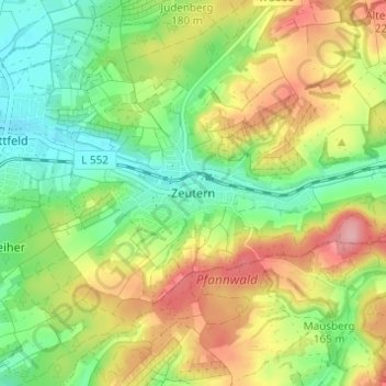
Name: Zeutern topographic map, elevation, terrain.

Location: Zeutern, Ubstadt-Weiher, Landkreis Karlsruhe, Baden-Württemberg, 76698, Germany (49.15647 8.65520 49.19647 8.69520)

Average elevation: 558 ft

Minimum elevation: 381 ft

Maximum elevation: 794 ft

Other topographic maps

Click on a map to view its topography, its elevation and its terrain.

Gear up for your next adventure:

🥇GPS Hiking Watch - Multi‑sport GPS watch with navigation and trail tracking
📶Satellite Messenger - Communication device off‑grid
🪶Wildlife Field Guides - Learn animal tracking and species ID
🗺️Topographic Maps - Detailed topo maps for hiking, exploring and outdoor navigation
🏕️Family Camping Gear - Essentials for group camping trips

As an Amazon Associate, this site earns from qualifying purchases at no extra cost to you.